Table of Contents
What Is Urban Design?
Urban design is the discipline concerned with shaping the physical form, character, and function of cities, towns, and villages. It operates at the scale between individual buildings (architecture) and entire metropolitan regions (planning), focusing on how streets, blocks, parks, plazas, and building arrangements work together to create places where people actually want to be.
The Scale That Matters Most
Architecture deals with individual buildings. Urban planning deals with policy, zoning, and land use at the city or regional scale. Urban design sits in between — and arguably, it’s the scale that affects your daily life more than either.
Think about it this way. The most beautiful building in the world, surrounded by a parking lot on a six-lane highway, is a miserable experience for anyone not inside it. Conversely, a street lined with mediocre buildings can feel wonderful if the proportions are right, the sidewalks are wide, the trees provide shade, and there are places to sit and watch the world go by.
Urban design asks: How wide should this street be? How tall should buildings be relative to the street width? Where should the trees go? What happens at the corner? How do people cross from one side to the other? These questions sound mundane until you realize they determine whether a neighborhood feels like a pleasant place to live or a hostile environment you escape from in your car.
The Elements of Urban Design
Streets and the Public Right-of-Way
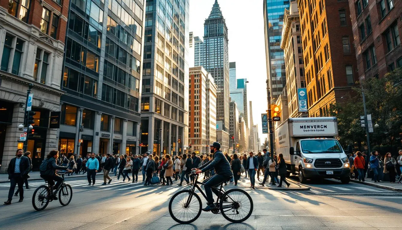
Streets consume 25-35% of a city’s land area. They’re the most common public space most people use every day. And yet, for most of the 20th century, streets were designed primarily — often exclusively — for cars.
The shift toward “complete streets” that serve pedestrians, cyclists, transit users, and drivers has been one of the biggest changes in urban design practice over the past two decades. A well-designed street might include separated bike lanes, wide sidewalks with street trees, transit lanes, outdoor dining zones, and travel lanes — all within the same right-of-way that used to be four lanes of traffic plus parking.
Street proportions matter enormously. The ratio of building height to street width — called the enclosure ratio — affects how a street feels. A ratio of about 1:1 (buildings as tall as the street is wide) creates a comfortable sense of enclosure. When the ratio drops below 1:3 (buildings much shorter than the street is wide), the space starts to feel exposed, windy, and unpleasant. This is why many suburban commercial strips feel terrible despite having shops — the buildings are one story tall, set back behind parking lots, and the road is six lanes wide. The proportions are all wrong.
Corner design is disproportionately important. Corners are where pedestrians cross, where sight lines converge, and where commercial activity concentrates. A tight corner radius forces drivers to slow down; a generous one lets them take turns at speed. Corner buildings with ground-floor retail and display windows create visual interest; blank walls or parking structures kill it. Some urban designers argue that getting corners right matters more than anything else.
Blocks and Parcels
The block pattern — the arrangement of streets creating the grid (or network) of developable land — determines how permeable a neighborhood is to foot traffic. Short blocks (around 60-80 meters, like Portland’s famously walkable blocks at 61 meters) create more intersections, more route choices, and more corner locations for retail. Long blocks (200+ meters, common in suburban developments) reduce connectivity and make walking feel tedious.
Jane Jacobs made this argument in The Death and Life of Great American Cities (1961), and decades of research have confirmed it. Neighborhoods with shorter blocks have more walking, more retail activity, and — somewhat surprisingly — lower crime rates. More eyes on the street, more activity, more natural surveillance.
Buildings and Their Edges
Urban design cares less about what a building looks like from a helicopter and more about what it does at ground level. The concept of the “active edge” or “active frontage” is central: a building facade that engages the street with windows, doors, displays, and signs at pedestrian level. Compare a block with fifteen small shops, each with its own entrance and display window, to a block occupied by a single office building with a blank wall and a parking garage entrance. Same block. Wildly different experience.
Setbacks — the distance between a building and the street — affect this too. Zero-setback buildings that come right to the sidewalk edge create strong street walls and intimate pedestrian spaces. Deep setbacks with front parking lots destroy the street edge and make walking unpleasant. This is the fundamental urban design failure of most American commercial strips: the buildings are too far from the street to create any sense of place.
Parks and Open Space
Every city needs parks, but the type, size, and distribution of green space matters more than the total acreage.
Small pocket parks and plazas within a few minutes’ walk of every home are more valuable for daily use than large regional parks that require a car trip. Copenhagen’s Jan Gehl has shown that people will walk about 400-500 meters (roughly a 5-minute walk) to daily amenities. Beyond that distance, usage drops sharply.
The quality of edges matters as much as the quality of the park itself. A park surrounded by active building frontages, busy streets, and overlooking windows feels safe and alive. A park surrounded by blank walls, parking lots, and empty buildings feels dangerous — and often is. Frederick Law Olmsted understood this in the 1850s; modern research on Crime Prevention Through Environmental Design (CPTED) has formalized the principle.
A Brief History of Urban Design Ideas
The City Beautiful Movement (1890s-1920s)
Following the 1893 World’s Columbian Exposition in Chicago, the City Beautiful movement promoted grand civic spaces, monumental buildings, wide boulevards, and classical architecture. Daniel Burnham’s 1909 Plan of Chicago is the movement’s masterwork — it gave the city its lakefront park system, Michigan Avenue, and a unified civic center.
The movement had real successes (many of America’s best parks and civic spaces date from this era) and real weaknesses (it was elitist, expensive, and didn’t address housing for ordinary people).
Modernist Urbanism (1920s-1970s)
Le Corbusier’s “Radiant City” vision — towers in a park, separated functions, superblocks, elevated highways — dominated mid-20th-century urban design and did enormous damage.
The concept was seductive on paper: demolish crowded, “unsanitary” old neighborhoods and replace them with rational, sunlit towers surrounded by green space, connected by freeways. The resulting projects — Pruitt-Igoe in St. Louis, Cabrini-Green in Chicago, the Heygate Estate in London — became symbols of failure. Separating functions (housing here, shopping there, offices way over there) killed street life. Elevated highways destroyed neighborhoods. The green spaces between towers became wind-swept wastelands that nobody used.
Robert Moses in New York built expressways through thriving neighborhoods, displacing hundreds of thousands of residents. The Cross Bronx Expressway alone destroyed a large section of the South Bronx. These were urban design decisions — choices about the physical form of the city — with consequences that lasted generations.
Jane Jacobs and the Reaction
Jane Jacobs’s 1961 book The Death and Life of Great American Cities was the most influential critique of modernist urbanism ever written. She argued — based on careful observation of her own neighborhood in Greenwich Village — that the things planners considered “messy” and “obsolete” (mixed uses, short blocks, old buildings, high density) were actually what made cities safe, vibrant, and economically productive.
Her four conditions for generating diversity became gospel:
- Districts must serve more than one primary function (mixing residential, commercial, and institutional uses)
- Blocks must be short, creating frequent opportunities to turn corners
- Buildings must vary in age and condition (because new buildings can only be occupied by new, well-funded enterprises — old buildings host the small businesses, immigrants, and artists that make neighborhoods interesting)
- Density must be high enough to support diverse street life
Jacobs was right about most of this. The neighborhoods she championed — Greenwich Village, Boston’s North End — are now among the most desirable and expensive in their cities. The projects she fought against are mostly demolished.
New Urbanism (1980s-Present)
Andres Duany, Elizabeth Plater-Zyberk, and Peter Calthorpe formalized many of Jacobs’s insights (along with traditional town-planning principles) into the New Urbanism movement. Key principles: walkable neighborhoods with a five-minute walk to daily needs, mixed-use buildings, connected street networks, diverse housing types, and public transit orientation.
Celebration, Florida (developed by Disney) and Seaside, Florida (where The Truman Show was filmed) are famous New Urbanist projects. Critics argue the movement has produced mostly affluent enclaves rather than affordable, diverse communities. Fair point. But the design principles have influenced mainstream practice — most city planning departments now incorporate New Urbanist concepts in their guidelines, and the movement’s emphasis on walkability has become standard practice.
Contemporary Urban Design Challenges
Car Dependency and the Parking Problem
American cities dedicate a shocking amount of land to parking. Houston has an estimated 30 parking spaces for every resident. Los Angeles devotes roughly 14% of its incorporated land to parking — more than it dedicates to housing.
Minimum parking requirements in zoning codes are the main culprit. When a city requires every new apartment building to include 1.5 parking spaces per unit, it forces developers to build expensive parking structures that increase rents, spread buildings apart, and create dead frontages at street level. Many cities are now eliminating minimum parking requirements — Buffalo was the first major U.S. city in 2017, followed by Hartford, Minneapolis, and San Jose.
Climate-Responsive Design
Urban design increasingly accounts for climate impacts. Heat islands — urban areas that can be 5-10 degrees Celsius hotter than surrounding rural areas — are a growing health concern as temperatures rise. Design responses include street trees (a mature tree provides the cooling equivalent of about 10 room-sized air conditioners), light-colored paving materials, green roofs, and building orientations that maximize shade while allowing winter sun.
Stormwater management through “green infrastructure” — rain gardens, permeable pavement, bioswales — replaces pipes and drains with natural filtration. Philadelphia’s Green City, Clean Waters plan aims to manage stormwater runoff through field design rather than conventional gray infrastructure, saving an estimated $5.6 billion over 25 years.
Equity and Inclusion
Good urban design isn’t equally distributed. Wealthy neighborhoods get wider sidewalks, more trees, better parks, and better-maintained infrastructure. Low-income neighborhoods — disproportionately communities of color — get narrower sidewalks (or none), fewer trees, and parks that are poorly maintained when they exist at all.
The tree canopy disparity is measurable: a 2021 study published in PLOS ONE found that formerly redlined neighborhoods in U.S. cities have significantly fewer trees than non-redlined neighborhoods, resulting in higher surface temperatures and worse air quality. Urban design choices made 80 years ago — literally drawing lines on a map — continue to shape the physical environment today.
Addressing these disparities requires both new investment and community involvement in design decisions. The best contemporary urban design projects, like the 11th Street Bridge Park planned for Washington, D.C., explicitly address equity goals alongside design quality.
Measuring Success
How do you know if urban design is working? Modern practice uses several metrics:
Pedestrian counts measure foot traffic. Time-lapse photography and sensor data reveal how many people use a space, when they use it, and how long they stay. Jan Gehl’s Public Life surveys, first developed in Copenhagen in the 1960s, have been replicated in cities worldwide.
Walk Score rates the walkability of addresses based on proximity to amenities. Scores above 90 (“Walker’s Paradise”) correlate with higher property values, lower transportation costs, and better health outcomes.
Level of traffic stress measures how comfortable or stressful streets are for cyclists, accounting for speed, volume, and separation. Lower stress scores correspond to higher cycling rates.
The field is moving toward evidence-based practice — designing spaces based on data about how people actually behave, rather than assumptions about how they should behave. It’s a welcome shift, even if the process of collecting and analyzing that data adds time and cost to projects.
Urban design, done well, makes cities more pleasant, productive, equitable, and sustainable. Done poorly — or not done at all — it produces the car-dependent, fragmented, hostile-to-pedestrians environments that define too much of the built world. The difference is literally in the details: street widths, building setbacks, tree placement, corner radius. Small decisions, enormous consequences.
Frequently Asked Questions
What is the difference between urban design and urban planning?
Urban planning deals with zoning, land use policy, building codes, and regulatory frameworks — it's more about rules and systems. Urban design focuses on the physical form and experience of places — how streets, buildings, parks, and public spaces are arranged and relate to each other. Think of planning as deciding what goes where and how much of it, while design determines what it looks like, feels like, and how people move through it. In practice, the fields overlap significantly.
What makes a good public space?
Research by William Whyte and Jan Gehl identifies several common features: comfortable seating (moveable chairs outperform fixed benches), access to sunlight, protection from wind, nearby food vendors, a mix of activities, clear sightlines that feel safe, and edges where people can linger without feeling exposed. The best public spaces attract a diverse range of people at different times of day and year. A space that's empty is failing, no matter how attractive it looks.
How does urban design affect health?
Urban design has measurable health impacts. Walkable neighborhoods with mixed-use zoning are associated with lower obesity rates, reduced cardiovascular disease, and better mental health. Access to parks and green space lowers stress hormones and improves cognitive function. Street design that slows traffic reduces pedestrian fatalities. Poor urban design — car-dependent sprawl with no sidewalks or destinations within walking distance — contributes to sedentary lifestyles and social isolation.
Further Reading
Cite this article
APA
WhatIs.site. (2025). What Is Urban Design?. Retrieved May 27, 2026, from https://whatis.site/urban-design MLA
"What Is Urban Design?." WhatIs.site, July 15, 2025, https://whatis.site/urban-design. Accessed May 27, 2026. Chicago
WhatIs.site. "What Is Urban Design?." Last modified May 12, 2026. https://whatis.site/urban-design. HTML
<a href="https://whatis.site/urban-design">What Is Urban Design?</a> — WhatIs.site Related Articles
What Is Urban Planning?
Urban planning is the process of managing city growth through land use, zoning, and infrastructure decisions. Learn about methods, history, and zoning types.
technologyWhat Is Urban Development?
Urban development is the process of building, expanding, and improving cities. Learn about housing, infrastructure, economic growth, and redevelopment.
technologyWhat Is Civil Engineering?
Civil engineering designs and builds infrastructure like roads, bridges, and buildings. Learn about its branches, history, and how it shapes daily life.
philosophyWhat Is Aesthetics?
Aesthetics is the branch of philosophy studying beauty, taste, and art. Learn its history, key thinkers, and why it still shapes how we see the world.